Today's beginner task: have someone video record you doing a perfect launch, then a perfect landing.
Information here may be incorrect. Use it at your own risk and only if you waive any claims against those involved in providing it.
Brian Morris' Brief
An east-wind day — a different regime. The wind is coming off the desert to our east, so it's warmer, drier, and hotter, and this easterly/northeasterly pattern holds for a few days, so hydrate and stay on electrolytes. It's blue, high-pressure, and stable with a strong inversion, so the thermals are small and sharp-edged early — they have to work through the cap. The tasks are kept short and both finish at LongSword. The sweet spot is roughly 1–4 PM (model-dependent), with the wind picking up again around 5–6 PM.
This morning's read:
- No clouds → high pressure → stable, with a strong inversion holding everything down. You could see the contrast in the morning dust looking up the valley; it's harder to judge from the ground than from the mountain.
- About 6–8 mph east on launch with super-smooth air below — but the wind had already picked up aloft.
- Thermals will be small and sharp-edged, not necessarily rowdy — they just have harder edges punching through the inversion. It's the ratio of thermal strength to cross-wind that matters, not wind speed alone: 10 mph + a strong core can still climb clean; 10 mph + a weak, inverted core is disorganized.
East day — the rules change:
- Woodrat's launch only faces north and west; the other peaks face every direction. With a new wind direction, what worked Tuesday won't work today — re-read the terrain from scratch.
- Favor terrain where the wind hits the slope head-on (about 90°) — that's where thermals climb and ridge lift works. East and northeast faces are favored today; the east bowl at Woodrat Peak should work well.
- The west side is now leeward → possible rotor. It can still throw lee-side thermals (sun-warmed pockets rising into the air spilling over the back), so a west-side climb may look nice but be rock-and-roll. The north side of the spine is the safer bet.
- Use Windy or XC Skies plus the terrain: find the faces the wind climbs straight up, and check what's behind them for rotor.
The models & the window:
- RAP: nicer window about 1:00–3:00, lift 500–600 ft/min; it'll also show whether a more northerly influence is coming.
- HRRR: sweet spot about 2:00–4:00, climbing toward 7,000–8,000 ft later in the afternoon.
- Winds: east-northeast and stronger late morning (~12–13 mph at 11–1), lightening into the sweet spot, then picking up again around 5–6 PM. We want the wind to swing more north.
- Treat the models like three friends giving different forecasts — fly the day, see which one was right, and keep changing the plan. Watch the drift, not just the launch wind.
Launching on an east day:
- There's no easterly launch. Use the north launch (or angle across it to the northeast) with a strong, well-loaded wing, and stay away from the tree line — there's rotor behind it (stronger in stronger wind). It was smooth at ~6–8 mph this morning.
- If it's light, west cycles may let you launch west — just remember the working faces are NE/E.
- Read the wind before you commit: the gust differential tells you thermal strength (5→6 mph ≈ light; 5→10 mph ≈ strong), the lulls tell you how often thermals cycle through, and compression makes it slower right at the tree line. Sit five minutes and build the picture.
- Watch other pilots: how fast they track one way versus how slowly they claw back — the slow direction is into wind, and points to where the lift is.
Today's tasks (kept short):
- Beginner task: have someone video record you doing a perfect launch, then a perfect landing.
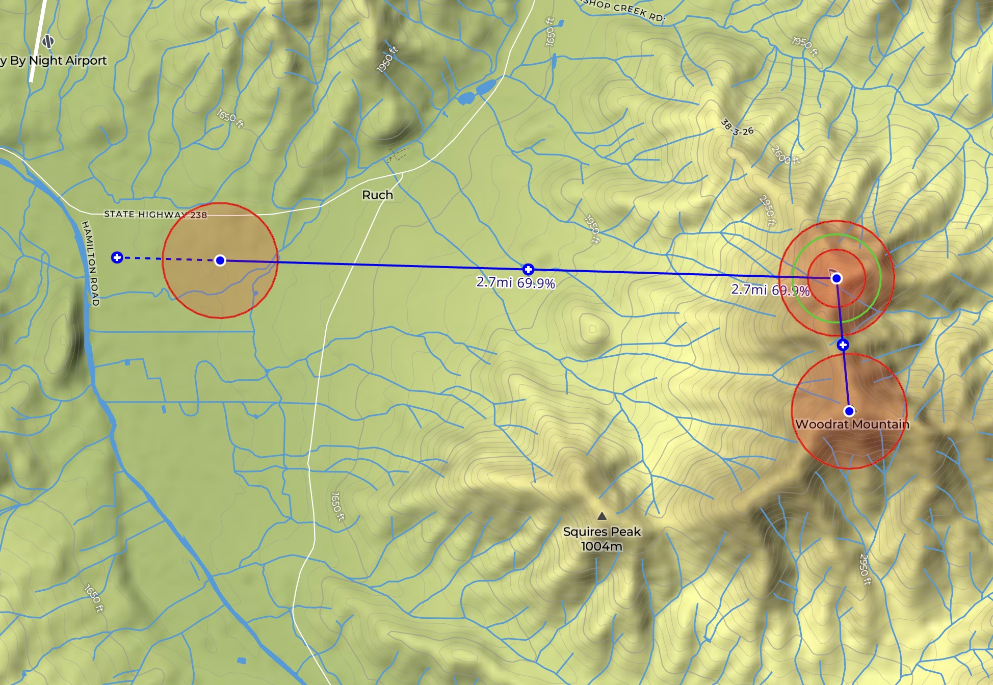
- Short task: launch → Woodrat Peak (work the east bowl and the opposite spine) → back to Woodrat Launch → LongSword.
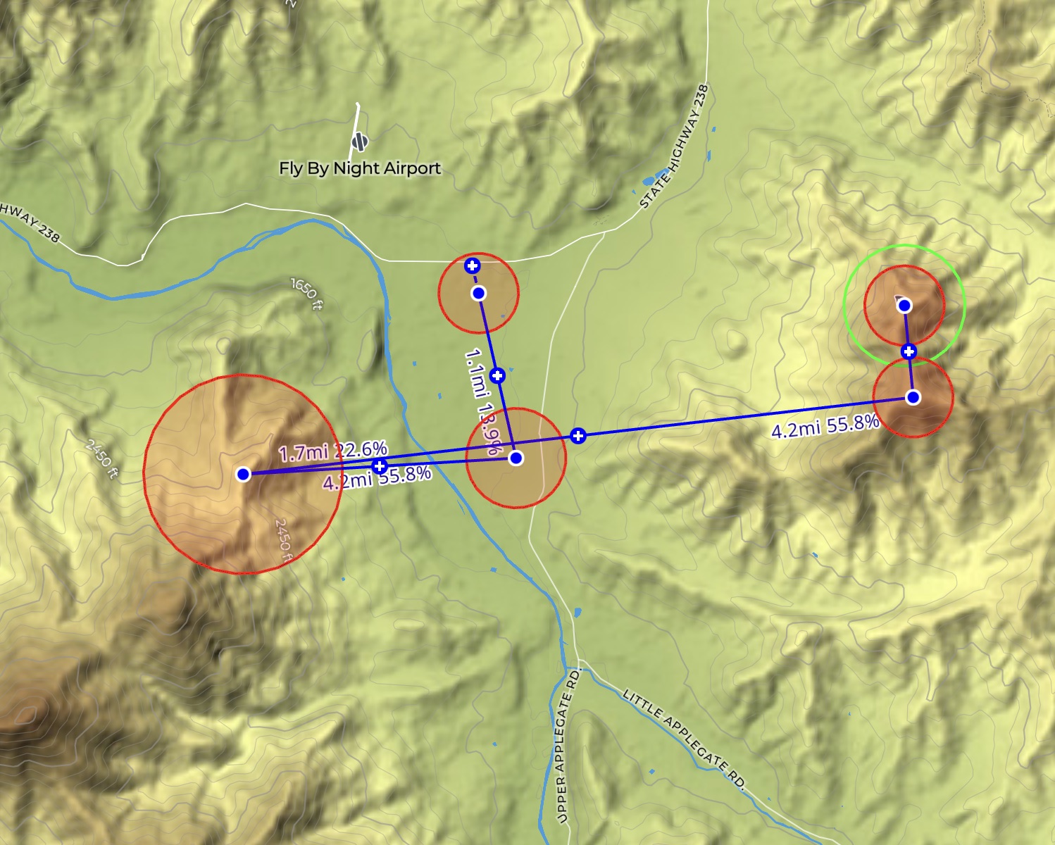
- Long task: launch → Woodrat Peak → Offenbacher → Wells → an upwind leg into LongSword. Time the upwind leg for the lighter window (RAP 1–3, HRRR 2–4). If you get low, stair-step — thermal up and glide forward — because you won't make it by climbing again in a strong northeast.
- Get really high over Woodrat Peak and feeling good? You can extend — but the tasks are short so everyone gets a fun window without being pushed into weird spots.
Coming into LongSword:
- Moving between valley systems, expect a westerly component. LongSword almost always blows west in the afternoon, so there's a convergence there — lots of lift, but also a possible rotor zone. Don't push too deep past LongSword if the west wind is up.
- The LongSword turnpoint is big — you can tag the river, come back to Wells, then the LongSword LZ.
- Arrive high when pushing into deeper terrain on a windy day; coming in low costs you. There's a lot going on at LongSword today.
Logistics
- Launch
- Woodrat Top Launch 42.23170, -123.00400
- Landing
- LongSword Vineyard LZ (today's landing) 42.23247, -123.05552
Alternate: Wells Land LZ 42.21754, -123.05055
Alternate: Hunter's Field LZ 42.24710, -123.02600 - Shuttle
- Shuttles run from LongSword up to Top Launch starting at 9:00 a.m.
- Radio
- 158.400 MHz primary; 151.925 MHz alternate.
- Report
- Within 15 minutes of landing, send "LOK" and your location to the Retrieve channel on the Rat Route 2026 Telegram group.
- Retrieve
- Post "#PUP" with your landing pin to the Retrieve channel on the Rat Route 2026 Telegram group, and wait with your wing packed.
Tasks
Optional learning routes for today. Each is a suggestion only — conditions, airspace, landowner rules, and your own judgment always come first.
Beginner
Short Task

Control table & coordinates
| # | Control | Role | Radius | Coordinates |
|---|---|---|---|---|
| 1 | WDLAUN Woodrat launch |
SSS | 400 m | 42.23135, -123.00362 |
| 2 | WOODRA Woodrat Peak |
TURNPOINT | 400 m | 42.22307, -123.00255 |
| 3 | WDLN-R Woodrat launch (return) |
TURNPOINT | 200 m | 42.23135, -123.00362 |
| 4 | LONSWD LongSword (goal) |
ESS | 400 m | 42.23247, -123.05552 |
Task map
Long Task

Control table & coordinates
| # | Control | Role | Radius | Coordinates |
|---|---|---|---|---|
| 1 | WDLAUN Woodrat launch |
SSS | 400 m | 42.23135, -123.00362 |
| 2 | WOODRA Woodrat Peak |
TURNPOINT | 400 m | 42.22307, -123.00255 |
| 3 | OFF-RG Offenbacher |
TURNPOINT | 1000 m | 42.21612, -123.08422 |
| 4 | WELAND Wells |
TURNPOINT | 500 m | 42.21758, -123.05095 |
| 5 | LONSWD LongSword (goal) |
ESS | 400 m | 42.23247, -123.05552 |
Task map
Map
Coordinate list
Woodrat Top Launch
42.231700, -123.004000
North and west launch faces. P3/H3; P2/H2 only with mentor or instructor sign-off.
Woodrat Mid Launch
42.241300, -123.014400
Southwest and northwest launch faces. P2/H2 minimum.
Hunter's Field LZ
42.247100, -123.026000
Working cattle field. Use only the currently designated landing area and follow all posted rules.
LongSword Vineyard LZ
42.232800, -123.055300
Building rotor is possible near the northwest corner. A headwind can increase near Ruch and LongSword.
Wells Land LZ
42.217540, -123.050550
Confirm the current waypoint and permission before use.
Woodrat Mountain
42.223009, -123.002176
Summit; the launch sits on its NW flank. 4124 ft, ~0.6 mi from Top Launch. USGS GNIS reference, not field-verified.
Squires Peak
42.218330, -123.025560
3297 ft, ~1.4 mi NE of launch, adjacent to Woodrat. USGS GNIS coordinate, not field-verified.
Ben Johnson Mountain
42.204491, -123.093380
4393 ft, ~5.0 mi W of launch (officially renamed from a former name in 2020). USGS GNIS reference, not field-verified.
Wellington Butte
42.262220, -123.106940
3710 ft, ~5.7 mi WNW of launch. USGS GNIS reference, not field-verified.
Anderson Butte
42.201620, -122.897083
5177 ft, ~5.9 mi E of launch. USGS GNIS reference, not field-verified.
Mount Baldy
42.194120, -123.110417
4980 ft, ~6.0 mi WSW of launch (Ruch quad; distinct from Baldy Mountain to the north). USGS GNIS reference, not field-verified.
Baldy Mountain
42.313472, -123.067917
3980 ft, ~6.5 mi N of launch (Mount Isabelle quad; distinct from Mount Baldy to the south). USGS GNIS reference, not field-verified.
Sugarloaf
42.283610, -123.123890
~3116 ft (elevation approximate, DEM-derived), ~7.1 mi NW of launch. USGS GNIS coordinate, not field-verified.
Mount Isabelle
42.303194, -123.104768
4498 ft, ~7.1 mi NW of launch. USGS GNIS reference, not field-verified.
Timber Mountain
42.324720, -123.069440
4416 ft, ~7.3 mi N of launch. USGS GNIS reference, not field-verified.
Tallowbox Mountain
42.195972, -123.151806
4980 ft, ~8.0 mi WSW of launch. USGS GNIS reference, not field-verified.
Palmer Peak
42.149491, -123.161806
4741 ft, ~9.9 mi SW of launch (near the 10-mi edge). USGS GNIS reference, not field-verified.
Jim Mee Peak
42.170787, -123.178750
4383 ft, ~9.9 mi WSW of launch (near the 10-mi edge). USGS GNIS reference, not field-verified.
LongSword Vineyard
42.232964, -123.056015
Evening venue (Jun 8 & 13).
Valley View Winery
42.224978, -123.049427
Evening venue (Jun 9).
Apple Outlaw Taproom
42.256612, -123.168420
Evening venue (Jun 10).
Red Lily Vineyards
42.238441, -123.115476
Evening venue (Jun 11).
Cowhorn Vineyard & Garden
42.154607, -123.047309
Evening venue (Jun 12).